Nassau, The Bahamas – The Bahamas Postal Services will release a new series of stamps on July 21 in celebration of the 10thanniversary of Bahamas National Geographic Information Systems Centre (July 26, 2004).
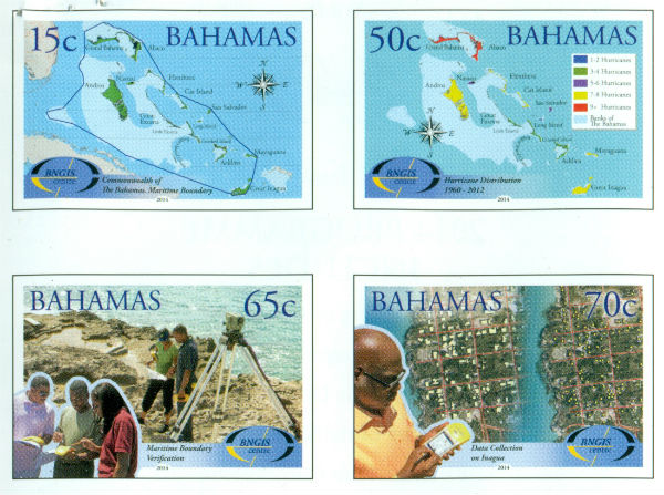
The special issue of four stamps features a 15 cent stamp, a 50 cent stamp, a 65 cent stamp and a 70 cent stamp.
The maps and photography featured on the stamps are by Carol Albury, Duane Miller, Antonique Strachan of BNGIS Centre.
The students depicted on the First Day Cover are the Centre’s official Banner Students from Sadie Curtis Primary School. The banner is displayed at all BNGIS hosted events as it captures students’ enthusiasm towards Geography and the Centre’s commitment to advancing GIS literacy in the school system.
BNGIS Centre was reactivated on July 26, 2004. Ms. Albury, director, and Mr. Miller and Mrs. Strachan, technical staff, formed the core team of advocates advancing the infusion of spatial technologies.
The mission of BNGIS is to promote, educate, coordinate and advance the practical and efficient use of GIS in The Bahamas.
BNGIS is mandated to serve as the Government’s technical focal point for Geospatial data and central repository for the collection, analysis and management of geographical data on The Bahamas; to provide GIS training, technical support and a national framework for GIS implementation.
15 cent Stamp “Commonwealth of The Bahamas Maritime Boundary”: The delimitation of the maritime boundaries of The Bahamas was identified in a White Paper on Independence as indispensable to its territorial integrity and sovereignty and an important objective to be achieved.
The official establishment of The Bahamas maritime border was achieved in December 2008. This significant step in the history of The Bahamas definitively set out the extent of archipelagic waters to which the full sovereignty of The Bahamas extends, subject only to certain rights of other States, such as “innocent passage”.
50 cent stamp “Hurricane Distribution 1960-2012”: The Bahamas comprises an archipelago of some 700 islands and over 2,000 cays and rocks with a total land area of 5,833 sq. miles which extends over 100,000 sq. miles of shallow banks and ocean.
The Bahamas is subjected to the impact of extreme hydro meteorological events including tropical storms, hurricanes, tornadoes, water spouts, coastal inundation due to storm surges and localized flooding.
Geospatial technologies have been used during all phases of the disaster preparedness process including the planning of shelter locations, production of hurricane maps, damage assessment, routing and evacuation maps and recovery efforts.
65 cent Stamp “Maritime Boundary Verification”: In 2004/2005 the BNGIS Centre was officially engaged by the Ministry of Foreign Affairs to assist in advancing in obligations to the United Nations Convention on Laws of the Sea (UNCLOS). Field verification exercises were required to check the veracity of some of the base points used to create the maritime baseline.
The 65 cent stamp depicts the BNGIS, in collaboration with the Royal Bahamas Defence Force conducting one of several field verification patrols. The Centre was the technical lead for verification patrols, CARISLots software training, map reproduction and technical support. This work resulted in an illustrative chart and list of geographical coordinates of points defining the archipelagic baselines, as contained in the Archipelagic Waters and Maritime Jurisdiction (Archipelagic Baselines), Order 2008.
70 cent Stamp “Data Collection on Inagua: Spatial technologies are appreciated worldwide as critical tools for managing a diverse range of business applications including utility management, disaster preparedness, national security, healthcare, land use and marine management.
BNGIS Centre used GIS and GPS during Data Collection exercises in Inagua where field observations or ground trothing were required. This base information is a prerequisite for conducting scientific research and planning.
The 2014 programme also includes the following special issues:
*The Christening of Prince George
*The 75th anniversary of the First Under Sea Post Office
*50th Anniversary of the Ministry of Tourism
*Bahamas Film Commission
*Christmas 2014.