|

|
|
|
Last Updated: Feb 13, 2017 - 1:45:37 AM |
AccuWeather Global Weather Center -- 25 August 2014 -- AccuWeather reports Tropical Storm Cristobal is forecast to become a hurricane and impact the Atlantic beaches of the United States with hazardous conditions.
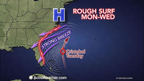
Cristobal is forecast to stay east of the U.S. this week as it gradually strengthens to become a hurricane. However, the Atlantic coast will not be free of impacts from the tropical system.
"Even through Cristobal will stay east of the Atlantic coast of the U.S., a strong tropical storm or hurricane will generate swells that propagate outward and will reach the shoreline in the form of rough surf and strong rip currents during the last week of August," warned AccuWeather.com Senior Meteorologist Alex Sosnowski.
Bathers trying to get in one last vacation before summer comes to a close would be at risk for such hazardous seas from Florida to North Carolina during the early and middle part of the week. Surf will build through Wednesday and possibly Thursday in these locations.
The rough surf will spread to the Northeast beaches from Virginia to Massachusetts prior to the start of the Labor Day weekend. However, the same weather system set to erase the forecast surge of warmth in the Northeast should work to protect the Northeast from direct impact by Cristobal.
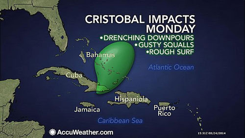
Heavy Rain to Exit Bahamas, Take Aim on Bermuda
As Cristobal developed during Friday and into the weekend, the system unloaded an average of 3 to 6 inches of rain on Puerto Rico and the Virgin Islands. The runoff caused multiple incidents of flash flooding.
Cristobal will continue to spread torrential downpours, gusty squalls and rough surf primarily from the Turks and Caicos islands to the southern Bahamas through Monday. Some drenching showers and thunderstorms will reach eastern Cuba.
Locally gusty thunderstorms can become strong enough to cause tree damage, some structural damage and power outages.
As the storm drifts northward during the middle of the week, the rainfall and winds will diminish over the region.
According to AccuWeather Hurricane Expert Dan Kottlowski, "Cristobal has the potential to bring heavy rainfall and gusty winds to Bermuda later this week, on top of what has been a wet month for the islands."
Rainfall in Bermuda, which has been close to 6 inches, is about 150 percent of normal for August.
"Even if the center does not directly pass over Bermuda, a broad flow of moisture and gusty winds can affect the islands for a few days," Kottlowski said.
Steering Winds to Keep Cristobal Away From US
Cristobal will generally track along the western periphery of the Atlantic ridge of high pressure.\
Two doses of offshore winds will impact the path of Cristobal this week.
After a slow northward drift into Monday, Cristobal should pick up some forward speed and curve to the northeast as the week progresses.
A southward dip in the jet stream (strong winds in the upper atmosphere) along the Atlantic coast of the U.S. is preventing Cristobal from moving closer to Florida.
Cristobal is forecast by AccuWeather meteorologists to track parallel to but off of the U.S. southeast coast Tuesday through Thursday. During this time, the atmosphere will be favorable for strengthening and Cristobal could become a hurricane.
A second southward dip in the jet stream along the Atlantic coast is forecast to sweep the storm farther out to sea late this week.
The latest forecast puts the center of Cristobal on a track just north and west of Bermuda late this week. However, there is potential for the storm to take a quicker turn to the northeast and take direct aim at Bermuda continues to be monitored.
Keeping an Eye on Other Systems
Elsewhere in the Atlantic, another system is being monitored for development.
"A disturbance crossing the central Atlantic early this week has the potential to become the next tropical depression or storm late this week as it nears the Caribbean," Kottlowski said.
At this point in the season, water temperatures are sufficiently warm to support tropical systems over much of the basin.
"The warm water is probably enough to override moderate wind shear and dry air," Kottlowski said.
While the Atlantic has come to life, the Eastern Pacific remains very active and has produced the strongest hurricane in years. Marie peaked as a Category 5 hurricane on Sunday with maximum sustained winds of 160 mph.

© Copyright 2014 by thebahamasweekly.com
Top of Page
|
|
|
|