From:TheBahamasWeekly.com
Gonzalo to Become a Major Hurricane, Eye Bermuda
By Alex Sosnowski, Expert Meteorologist for AccuWeather.com
Oct 14, 2014 - 5:52:47 PM
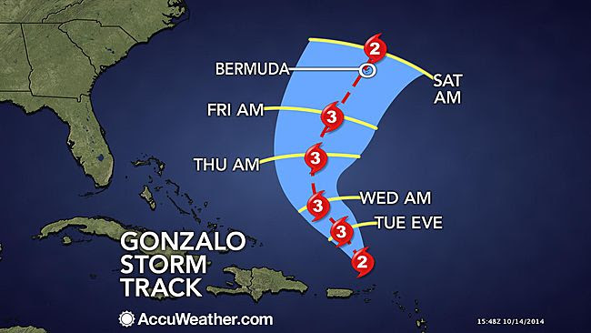
AccuWeather reports after lashing the northern Lesser Antilles as a powerful hurricane, Gonzalo is on the verge of becoming a major hurricane.
Gonzalo unleashed torrential rain and damaging winds to Antigua and other islands of the northern Lesser Antilles.
Impacts to the northeast Caribbean will fade Tuesday as Gonzalo moves north toward Bermuda over the next several days.
"Residents of Bermuda should make preparations for a potential direct hit from Gonzalo later this week," said AccuWeather.com Meteorologist Steve Travis.
A direct hit on Bermuda could happen late Friday night into Saturday with sustained winds of 120 mph and higher gusts possible.
"Extensive damage to property and infrastructure is possible later this week," added Travis. "Travelers to Bermuda may want to plan to leave no later than Friday morning."
A cold front will steer Gonzalo on a more northerly path this week.
Torrential rain and damaging winds recently battered Bermuda as then Tropical Storm Fay passed nearby last Saturday night and Sunday morning. A peak wind gust to 82 mph was measured.
Fay lost all tropical characteristics late Monday afternoon across the open waters of the northern Atlantic.
During October, on average, areas most likely for tropical development in the Atlantic Basin tend to shift closer to the nearshore waters of North and Central America.
The Atlantic is behind the curve for the average number of named tropical systems. After about a three-week lull, Fay and Gonzalo recently brought the number of named storms to seven. On average, there are nine named systems over the Atlantic by the middle of October.
With 18 named systems this season, the eastern Pacific is running ahead of the average. By the middle of October, the average number of named systems is 15.
© Copyright 2014 by thebahamasweekly.com -