|

|
|
|
Last Updated: Feb 13, 2017 - 1:45:37 AM |
Saharan dust
|
For the month of
July so far, we have received just 0.02 inches of rain at LPIA (the majority of
the days basically reported no rain or simply just a trace). The climatological
average at
Lynden
Pindling International Airport
(LPIA) for the month of July is 5.89 inches. A key reason
for the lack of rain, and even lack of clouds, is dry air streaming all the way
from the Sahara Desert in Africa. Huge plumes of dusty dry mid-level air make
their way across from the far eastern Atlantic, over the Caribbean and
Antilles, and sometimes to the southeast U.S. We can identify such days by a
hazy, milky sky and a suspicious absence of afternoon clouds and thunderstorms.
Yes, it looks like another event of Saharan dust
will be over us for the next three to four days minimum, at least keeping
significant rainfall activity at a bare minimum. This dry Saharan dust plume
makes the sky appear milky white and the boundary of the clouds appears to be
blending in with the milky white sky.
During this Sahara dust ‘event’ it
tends to significantly inhibit convective activity (thunderstorms and
showers)-It doesn’t prevent them all together but it significantly lessens
their activity. It also gives the sun a very noticeable 'red hue' especially at
sunrise and sunset. This is the same dust in the
atmosphere that prevented significant above average tropical cyclone
development for the last two to three years over the North Atlantic. All the
haze shrouding The Bahamas this week may not be great for your health, but it
has a major benefit: It helps stymie hurricanes and tropical storms. The haze
actually is Saharan dust that drifted more than 4,000 miles from Africa, and
abnormally heavy concentrations currently are blanketing the main region of the
Atlantic where storms develop (see charts). The dust, denies the systems of
their lifeblood - heat and moisture.
In The
Bahamas, the dust is expected to remain thick, possibly for the rest of the week.
It has lowered air quality from good to moderate range. If you have extreme
respiratory problems, stay inside air-conditioned facilities to minimize
exposure. Anyone who works outside for any length of time also should be
careful because of the combination of dust and high heat. Dust outbreaks occur
when strong winds lift clouds of particles from the Sahara Desert. Winds or
tropical waves – areas of low pressure – then push the dust plume west across
the Atlantic. Because the Sahara has been super heated this year, making its
surrounding atmosphere unstable, the dust outbreaks have been more frequent and
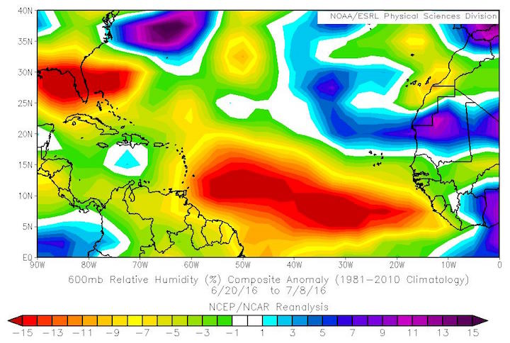
expansive than usual. The plot shows the mid-level relative humidity anomaly
over the past three weeks
(Images courtesy of NOAA-NCEP/NCAR/Brian McNoldy),
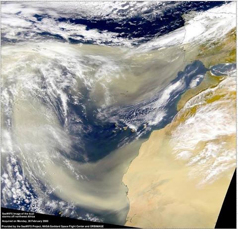
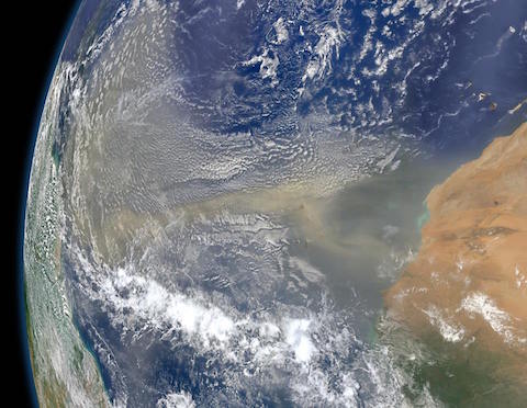
and the satellite images are examples of what these plumes actually look like
from space.
African dust
|

© Copyright 2016 by thebahamasweekly.com
Top of Page
|
|
|
|