|

|
|
|
Last Updated: Feb 13, 2017 - 1:45:37 AM |
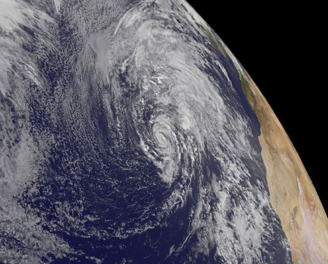
Hurricane Alex (Image: National Hurricane Center)
|
Alex has become a hurricane near the Azores in the middle of the North Atlantic Ocean. It marks the first North Atlantic hurricane to form in the month of January since 1938 and is the first North Atlantic hurricane to exist during January since Alice in 1955. Alex formed in the North Atlantic Ocean on Wednesday, making it one of the earliest tropical systems to form in the Atlantic Hurricane Basin since records began in 1851. History spun up over the far reaches of the Northeast Atlantic on Thursday, as Subtropical Storm Alex carved out a distinct eye within a core of intense thunderstorms, making it Hurricane Alex.
The 10 am EST advisory from the National Hurricane Center put Alex’s sustained winds at 85 mph. Alex was located about 500 miles south of Faial Island in the Azores, moving north-northeast at 20 mph. A hurricane warning is in effect for the islands of Faial, Pico, Sao Jorge, Graciosa, and Terceira in the central Azores. Given the strong steering currents driving Alex, there is high confidence that at least some of the central Azores will experience tropical storm or hurricane-force wind, heavy rain, and high surf. To get a hurricane making landfall in the Azores any time of year is extremely unusual (about once per 10-20 years); to get a landfall in January would be truly remarkable.
In records going back to 1851, only two hurricanes are known to have existed in the North Atlantic during the month of January: an unnamed tropical storm that became Hurricane #1 on January 4, 1938, and Hurricane Alice, which maintained hurricane strength from December 31, 1954, to January 4, 1955. Alice topped out at 80 mph, so Alex is officially the strongest January hurricane on record in the North Atlantic. Much like Alice, another tropical cyclone--Tropical Storm Zeta of the very active 2005/06 hurricane seasons--formed in December and extended into January, and a tropical storm was recorded in early January 1951. There was also a subtropical storm in January 1978.
The National Hurricane Center in Miami categorized it a subtropical storm on Wednesday, Alex took on a surprisingly healthy structure overnight, with a symmetric core of showers and thunderstorms around its clear-cut eye. According to Bob Henson and Dr. Jeff Masters of private weather company Weather Underground in the United States, “Sea-surface temperatures beneath Alex are only around 20-22°C (68-72°F). Although these are up to 1°C above average for this time of year, they are far cooler than usually required for tropical cyclone development. However, upper-level temperatures near Alex are unusually cold for the latitude, which means that instability--driven by the contrast between warm, moist lower levels and cold, drier upper levels--is higher than it would otherwise be. That instability allowed showers and thunderstorms to blossom and consolidate, strengthening the warm core that makes Alex a hurricane as opposed to an extratropical or subtropical storm.”
Alex’s unusual life as a January hurricane will be a short one. The system is already accelerating northward ahead of a strong upper-level trough, and by late Friday it should be a powerful post-tropical low racing toward Greenland. Even though Alex will become absorbed in the higher-latitude storm system, its warm, moist air may assist in pushing temperatures over parts of Greenland more than 35°F above average this weekend into early next week.
One may ask? Which year should Alex belong to? One might argue that Alex is actually dawdler storm from the 2015 North Atlantic hurricane season, rather than the first storm of 2016. Tropical sea-surface temperatures north of the equator typically bottom out around March, so there might be some physical rationale for defining the North Atlantic hurricane “years” as being from March 1 to February 28/29. In practice, though, there are very few tropical cyclones in January and February, so in most years this switch would make no difference, and it could foster public misunderstanding of this storm and others like it. There is a much stronger physical justification for the practice of straddling hurricane seasons across calendar years in the Southern Hemisphere, where summer arrives in late December and cyclones often form before January 1.
Hurricane Alice from 1954-55 is an interesting case in itself. It was originally recognized as a hurricane and named Alice on January 2, 1955. At that point, the same lists were being used from year to year, and there had already been a deadly Hurricane Alice in June 1954, so the 1954 North Atlantic hurricane season has two named hurricanes called Alice and is the first and only time this occurred. However, post-storm analysis determined that the latter Alice had been a hurricane on December 31, 1954.
A subtropical storm has both tropical and non-tropical characteristics and has a large wind field. Subtropical Storm Alex formed on Wednesday in the eastern Atlantic Ocean, giving the 2016 hurricane season a rare January start. The Atlantic hurricane season officially runs from June 1 through November 30, but storms have, on an occasional basis, formed before and after that date. It's only the fourth time a storm has formed in January since 1851, according to the National Hurricane Center. The Azores could see rainfall amounts of 3 to 5 inches through Friday, with some areas getting as much as 7 inches from this storm. Meteorologists warn this could lead to flash floods and mudslides. Gale-force winds are expected to drench the archipelago Friday.
Alex is forecast to move northeast and north through the eastern Atlantic Ocean the next few days. A subtropical cyclone displays features of both tropical and non-tropical systems, including a broad wind field, no cold or warm fronts, and generally low-topped thunderstorms displaced from the center of the system. A small eye formed in the system during early Thursday, local time. Alex has made the transition from a part tropical and non-tropical system to a full-featured tropical system. Alex is located well in the eastern Atlantic Ocean and doesn't pose a threat to The Bahamas; however, it will affect the Azores, Alex will bring damaging winds and the risk of flooding to the Azores. Alex is the first tropical system to form over the North Atlantic Ocean in January since Subtropical Storm One in 1978. The earliest tropical storm to form in January was Storm #1 on January 3, 1939.
Early Season Tropical/Subtropical Storms
How unusual is this Subtropical Storm/Hurricane Alex? According to the National Hurricane Center records, Alex is the first tropical or subtropical storm to form in January since 1978. It's also only the fourth known storm to form in January since official records for the North Atlantic began in 1851. Based on the long-term average, about once every 10 years, a tropical storm forms before June-the beginning of the North Atlantic hurricane season, most often in the month of May. This includes Tropical Storm Ana, which began as a subtropical storm in early May of 2015, eventually transitioning into a tropical system. Likewise, roughly once every 10 years, a tropical storm has formed in the month of December. Post-season and pre-season tropical systems are usually relatively weak, in part due to cooler sea-surface temperatures (lower than the threshold temperature of 26.5°C for tropical storms or hurricanes to form) in the winter and spring months, restricting the ability for such storms to intensify.
The last time a tropical/subtropical cyclone existed in January was in 2006 (Zeta, which formed late December 2005). There are archival records that January systems formed in 1938, 1951, lasted into January 1955 (Alice), and mid-January 1978 (unnamed subtropical storm). However, there was a system in early January 1992 which is up for consideration to be added into the tropical cyclone database, which struck during a Washington Redskins playoff football game in the United States.
What is the difference between a Tropical Storm and a Subtropical Storm?
"Tropical cyclone" is a meteorological term. The adjective "tropical" refers to both the geographic origin of these systems, which form almost exclusively in tropical regions of the globe, and their formation in Maritime Tropical air masses. The noun "cyclone" refers to such storms' cyclonic nature, with counterclockwise rotation in the Northern Hemisphere and clockwise rotation in the Southern Hemisphere. Depending on their location and strength, there are various terms by which tropical cyclones are known, such as hurricanes, typhoons, tropical storms, cyclonic storms, and tropical depressions.
Tropical cyclones can produce extremely strong and powerful winds, tornadoes, torrential rain, high waves, and storm surge. They are born and sustained over large bodies of warm water, and lose their strength over land. This is the reason coastal regions can receive significant damage from a tropical cyclone, while inland regions are relatively safe from receiving strong winds. Heavy rains, however, can produce significant flooding inland, and storm surges can produce extensive coastal flooding up to 25 miles inland. Although their effects on human populations can be devastating, tropical cyclones can also relieve drought conditions. They carry heat away from the tropics to the poles (a cold front does the exact opposite), an important mechanism of the global atmospheric circulation that helps maintain equilibrium in the Earth's troposphere. Many tropical cyclones develop when the atmospheric conditions around a weak disturbance in the atmosphere are favorable. Others form when other types of cyclones acquire tropical characteristics. Tropical systems are then moved by steering winds in the troposphere; if the conditions remain favorable, the tropical disturbance intensifies, and can develop an eye. On the other end of the spectrum, if the conditions around the system deteriorate, or the tropical cyclone makes landfall, the system weakens and dissipates.
On the other hand, a subtropical cyclone is a weather system that has some characteristics of a tropical cyclone and some characteristics of an extratropical cyclone. They can form in a wide band of latitude, from the equator to 50°N in the Northern Hemisphere. A subtropical cyclone is a non-frontal low-pressure system that has characteristics of both tropical and extratropical cyclones. Like tropical cyclones, they are non-frontal, synoptic-scale cyclones that originate over tropical or subtropical waters, and have a closed surface wind circulation about a well-defined center. In addition, they have organized moderate to deep convection, but lack a central dense overcast. Unlike tropical cyclones, subtropical cyclones derive a significant proportion of their energy from baroclinic sources, and are generally cold-core in the upper troposphere, often being associated with an upper-level low or trough. In comparison to tropical cyclones, these systems generally have a radius of maximum winds occurring relatively far from the center (usually greater than 60 miles), and generally have a less symmetric wind field and distribution of convection.
Why such a late season storm?
Michel Davison lead Forecaster and Chief Coordinator of Administration at Weather Prediction Center, NCEP’s (the National Centers for Environmental Prediction) International Desk of the U.S. National Oceanographic Atmospheric Administration in Washington, DC stated that this storm was an unusual storm but formed because the conditions were just right for its formation. There was a significant amount of ‘stored-up energy’ in this region because it saw very little tropical cyclone activity in the 2015 North Atlantic hurricane season and the upper atmospheric conditions within this region were ideal for this subtropical storm to form.
Bryan Norcross, Hurricane Specialist at The Weather Channel and former CBS Evening News Hurricane Analysist stated that, “From the second half of the hurricane season on, the tropical and sub-tropical Atlantic have been warmer than normal, while the north Atlantic is much colder than normal. This is likely due to a weakening of the sub-tropical (Bermuda) high, and perhaps a number of other factors, maybe including some relation to the strong upper-level westerly wind anomalies caused by the strong El Nino. Who knows?” When asked if he thinks the formation of Subtropical Storm Alex is 'global warming' or 'climate change' related? He simply stated that, “a slow-moving low-pressure system ended up over those very warm waters and became organized enough to be sub-tropical. It happens.Things come together.I don't think it is indicative of anything. The odds are the El Nino will fade, but the effects will be felt into the hurricane season next year. If you had to guess right now, you'd think the Atlantic might become more favorable later in the season... so perhaps a slow start like 1992. But, it's a wild guess. There are too many factors in play.”
Phil Klotzbach, meteorologist and lead hurricane researcher at Colorado State University, stated that, “In terms of Hurricane Alex, January Tropical Cyclones are fairly rare, although not unheard of. We had Zeta which formed in December 2005 and continued into January 2006. Alice formed in December 1954 and continued into January 1955. There have also been subtropical systems (similar to Alex) that developed in 1931, 1951 and 1978.”
According the Michael Stubbs, Chief Climatologist at the Bahamas Department of Meteorology, stated that the formation of this storm outside of the normal hurricane season is a clear indication that there is something abnormal in the earth’s atmosphere, and could be a clear indication of a rapidly warming planet or a sure sign of global warming. Another example, 2015 was the warmest year on record he claimed and Hurricane Alex only offers fuel to this debate.
About the Author
Wayne Neely is a best-selling author of 10 books on hurricanes, lecturer on hurricanes and is a certified Bahamian meteorologist working at the Department of Meteorology in Nassau, Bahamas for the last 25 years.

© Copyright 2016 by thebahamasweekly.com
Top of Page
|
|
|
|


