|

|
|
|
Last Updated: Feb 13, 2017 - 1:45:37 AM |
Tropical Storm Erika Batters Caribbean; Florida, Bahamas on Alert
By Kristina Pydynowski, Senior Meteorologist for AccuWeather.com
Aug 27, 2015 - 2:30:56 PM
|
Email this article
Mobile friendly page
|
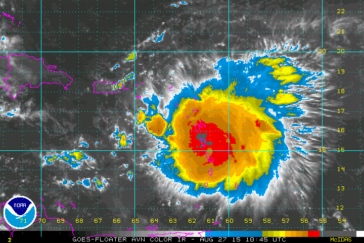
Satellite imagery of Erika (Image/NOAA)
|
AccuWeather Global Weather Center - August 27, 2015 - AccuWeather reports Erika will bring torrential rain, flash flooding, mudslides and gusty winds to many of the northern islands of the Caribbean, prior to taking a turn toward the Bahamas and Florida this weekend.
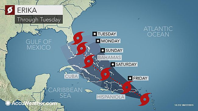
Erika remains a tropical storm spinning about 85 miles west of Guadeloupe, as of 8 a.m. EDT Thursday.
Erika Short-Term Impacts
Erika will pass through the Leeward and northern Windward islands on Thursday.
During Friday, Erika then will travel through the British and United States Virgin Islands and Puerto Rico.
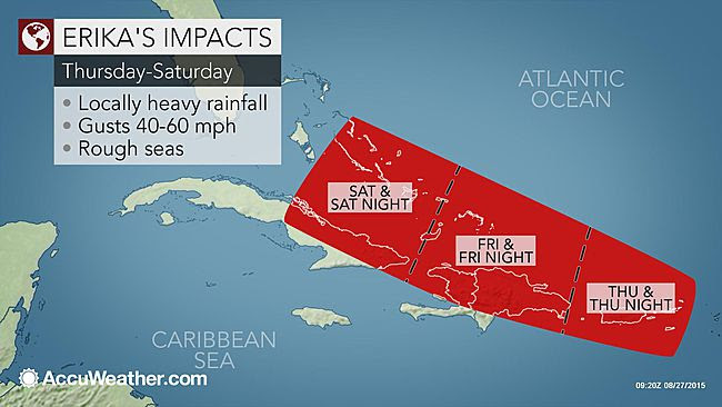
The greatest threat to lives and property will be from flash flooding and mudslides.
A general rainfall of 2-4 inches (50-100 mm) is forecast with locally higher amounts. On Puerto Rico and the northeastern part of the Dominican Republic, rainfall of 4-8 inches (150-200 mm) is likely with greater amounts falling on the mountains.
Flash flooding has occurred on some of the Leeward Islands. On the island of Dominica, a flooding disaster has occurred. At Canefield, Dominica, 8 inches of rain fell in six hours. Canefield received 2 inches of rain from Danny, just a few days earlier.
Winds will average between 40 and 60 mph (64 to 95 kph), with higher gusts. Seas will be dangerous for bathers and boaters. Winds of this strength can down trees, cause sporadic power outages and damage roofs and poorly built structures.
Erika Path and Intensity Concerns This Weekend, Next Week
All interests from the Bahamas to Florida and the Southeastern United States in general will need to monitor the track and strength of Erika into next week.
At minimum, surf and seas will increase from southeast to northwest across the Bahamas, the north side of Cuba and the southern and eastern coast of Florida this weekend.
There are multiple scenarios on the exact track and intensity of Erika once it clears the northern islands of the Caribbean. The possible tracks or window of movement ranges from the system slipping just to the west of Florida to right over Florida to curving to the east.
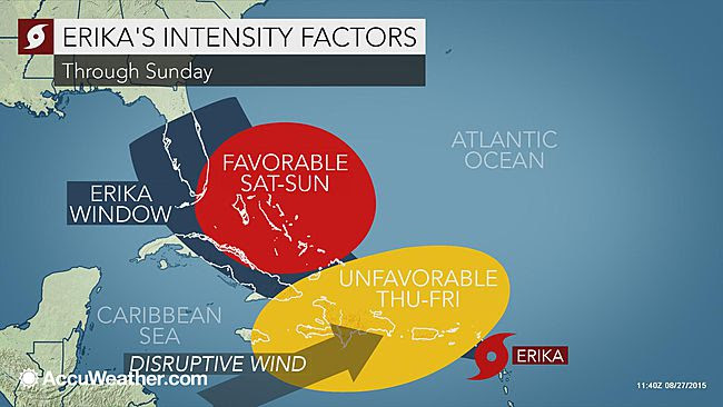
According to AccuWeather Hurricane Expert Dan Kottlowski, "Erika will have to survive strong wind shear and the frictional effects of the mountainous islands of Puerto Rico and Hispaniola."
Shear is the rapid change in the speed and direction of the wind from the surface of the earth to the middle layers of the atmosphere.
Should Erika weaken negotiating Puerto Rico and Hispaniola, it could totally fall apart or perhaps struggle to reorganize.
"Waters are warm enough and wind shear is weaker in the stretch from Florida to the Bahamas," Kottlowski said. "So, if it were to survive the gauntlet of Puerto Rico and Hispaniola, it could gather strength."
Should Erika strengthen rapidly, the system could curve along or east of the Atlantic coast of Florida.
How soon Erika makes more of a turn to the northwest and then to the north will determine the extent of impacts in the Bahamas and Florida. If the system survives as far north as Florida, there will be concerns farther north into the Southern states, especially in the Carolinas and perhaps as far west as Louisiana.
There is also the chance the system stalls along the Southeast U.S. coast after negotiating Florida waters.
Which scenario unfolds will depend on the strength of an area of high pressure set to build over the western Atlantic Ocean late this week and into the weekend. This high is the reason for the cooler air pouring into the Northeast late this week.
At this point, the amount of rain, wind and flooding from Erika in Florida and the Bahamas will depend on the exact track and strength of the system this weekend and into early next week.
The last hurricane to hit Florida was Wilma in October 2005.
"This is a good time for residents of the Bahamas and Florida to review hurricane plans," said Kottlowski. "If Erika does indeed target Florida, there will be a big rush to complete preparations this weekend. However, it takes time to do some things such as moving boats from marinas to safety."
"Be aware and do things now to mitigate flying debris," Kottlowski continued. "Even if Erika does not threaten, it is better to act on the side of caution now than wait."
The AccuWeather Hurricane Center will continue to provide information on Erika, as well as all other tropical features across all ocean basins.

© Copyright 2015 by thebahamasweekly.com
Top of Page
|
|
|
|