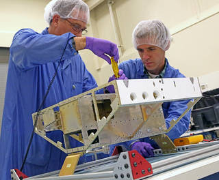
Engineers begin construction of the first of eight microsatellites for NASA’s Cyclone Global Navigation Satellite System at the Southwest Research Institute in San Antonio, Texas. Communication antennas, attitude control, GPS receiver, and other instrumentation will be installed on the satellite frame in the coming weeks.
Credits: SwRI
|
Ten years after
Hurricane Katrina formed in the Atlantic, construction of NASA’s
next-generation hurricane-observing satellite mission now is underway in
Texas.
NASA’s Cyclone Global Navigation Satellite System (CYGNSS) mission, a
constellation of eight microsatellites, will improve hurricane
forecasting by making measurements of ocean surface winds in and near
the eye wall of tropical cyclones, typhoons and hurricanes throughout
their life cycle.
CYGNSS will allow scientists to probe the inner core of hurricanes
from space frequently for the first time, using both direct and
reflected signals from existing GPS satellites to obtain estimates of
surface wind speeds over the ocean. These measurements will advance
forecasting methods by providing data that can lead to better
predictions of hurricane tracks, intensities and storm surges.
As the CYGNSS and GPS satellites circle Earth, their interaction will
provide anew image of wind speeds over the entire tropics every few
hours, whereas a single satellite supplies a new image every few days.
The ability to better monitor and predict the rapid changes in hurricane
intensity, such as those observed with Hurricane Katrina, is critical
to hurricane forecasters and U.S. coastal communities.
Earlier this summer, the CYGNSS mission successfully passed two major
NASA reviews, clearing the way for integration, testing and preparation
of the microsatellites for flight.
“These reviews were a major milestone for CYGNSS, marking the end of
the detailed design and planning stages of the mission and the beginning
of flight hardware assembly,” said Chris Ruf, CYGNSS principal
investigator at the University of Michigan, Ann Arbor. “We are now in
the last phase of the mission prior to launch and the beginning of a new
era in hurricane observations.”
The University of Michigan is directing the CYGNSS mission for NASA,
including satellite design and production and science data processing.
The CYGNSS constellation will be deployed into low-Earth orbit with
successive satellites passing over the same region approximately every
12 minutes. The Southwest Research Institute in San Antonio is building
and testing the CYGNSS microsatellites and will host the mission
operations center at its Boulder, Colorado location.
Assembly of the first microsatellite began Aug. 14, with the other
seven to follow in the next few weeks. The body of each satellite
measures roughly 20-by-25-by-11 inches, slightly larger than a standard
carry-on suitcase. When fully assembled, the satellites will each weigh
about 64 pounds. With the solar panels deployed, each microsatellite
will have a wingspan of 5.5 feet. The satellites will be stacked for
testing in early 2016.
The mission is scheduled to launch in late 2016 on an Orbital ATK
Pegasus XL expendable rocket from Cape Canaveral in Florida, with
science operations beginning in the 2017 Atlantic hurricane season.
CYGNSS is a NASA Earth Venture mission in the Earth System Science
Pathfinder program, managed by the agency’s Langley Research Center in
Hampton, Virginia. Other projects in the program include developing
high-return Earth science missions with advanced remote-sensing
instruments and frequently involve partnerships with other U.S. agencies
or international science and space organizations.
NASA uses the vantage point of space to increase our understanding of
our home planet, improve lives and safeguard our future. NASA develops
new ways to observe and study Earth's interconnected natural systems
with long-term data records. The agency freely shares this unique
knowledge and works with institutions around the world to gain new
insights into how our planet is changing.
For more information on NASA’s Earth science activities, visit:
http://www.nasa.gov/earth


