|
From:TheBahamasWeekly.com International
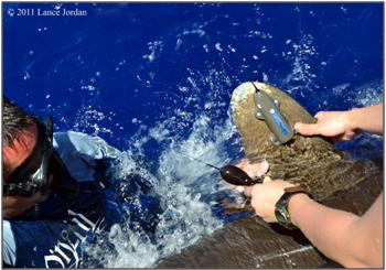
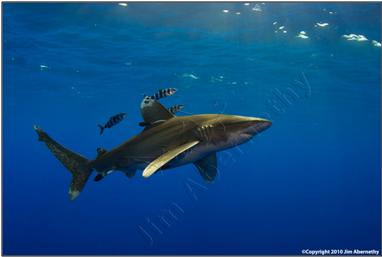
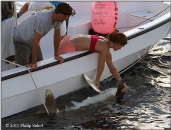
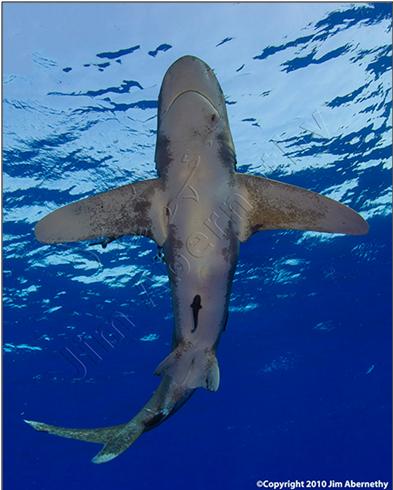
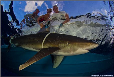
The oceanic whitetip shark ( Carcharhinus longimanus) was once considered to be one of the most numerous large vertebrates on the planet. Yet ongoing exploitation of this species for it fins, for use in the Asian delicacy shark fin soup, has caused precipitous population declines in many parts of the world. This species has been especially hard-hit in the northwest and western central Atlantic Ocean, where it is now difficult to find them in significant numbers. Despite the inherent difficulties in finding and studying large, relatively rare oceanic sharks, an international team of researchers successfully satellite-tagged a large number of these animals off Cat Island, The Bahamas, this month in order to track their movements to enable more effective conservation of this top ocean predator. Edd Brooks, Annabelle Oronti and Sean Williams of the Shark Research and Conservation Program at the Cape Eleuthera Institute , Lucy Howey-Jordan and Dr. Lance Jordan of Microwave Telemetry, Inc. , Stuart Cove and the staff of Stuart Cove’s Dive Bahamas , Dr. Demian Chapman of Stony Brook University and Debra Abercrombie of Abercrombie & Fish, undertook a 10-day expedition to Cat Island to conduct the first instalment of a long-term project to study the movements and habitat use of oceanic whitetips. “I have been trying to get down to the Cat Island aggregation since the Shark Research and Conservation Program was founded five years ago, and now, with the incredible support offered by Microwave Telemetry and Stuart Cove and his staff, we have finally got our chance. This species is one of the most endangered pelagic sharks in the world, yet virtually nothing is known about its basic biology and ecology, something this project will hopefully change.” said Edd Brooks, Program Manager of the Shark Research and Conservation Program at Cape Eleuthera Institute . “This project has been a very unique collaborative initiative between shark diving operators and scientists. In addition to Stuart Cove’s generous support, we were very lucky to be assisted by Jim Abernethy of Jim Abernethy’s Scuba Adventures , who helped locate sharks during a couple of slow days, and Vinnie and Debra Canabal of Epic Diving who have been keeping an eye out for our tagged animals. The future success of the project will depend in part on the ongoing support of our partners in the shark diving industry.”
Oceanic whitetips grow to over 10 feet in length, but take at least 6-7 years to reach maturity, making them vulnerable to fishing pressure. Over the 10-day expedition, the research team captured and tagged the sharks with pop-up satellite archival transmitters (PSATs) to record depth, temperature and light-level data which are later transmitted to a satellite. The researchers then get emails that relay the shark’s estimated position, dive history and temperature profile over the life of the transmitter. Five of the 17 satellite tags deployed were experimental fin tags that will provide accurate, and near real-time, geo-location information over the next 18 months. Safety of the research team and the sharks themselves was paramount during the study and all sharks were held in the water during attachment of both types of satellite tags. Three of the captured animals have since been spotted during shark dives in the area and all appeared to be healthy and happy. “The technology to make this study a reality has been around for nearly 15 years and it’s a shame that it took so long to begin a thorough study of this dwindling species.” said Lucy Howey-Jordan, Scientific Liaison at Microwave Telemetry, Inc. “It required incredible efforts from our multidisciplinary team to make this project happen. Hopefully, the data we collect will aid fisheries managers in their decision making and give this species a real shot of rebuilding.” The Bahamas is widely credited as being a leader in shark conservation after banning longline fishing in the late 1990s. The opportunity to study the wide variety of species that exist here, both in deep and shallow water, in a relatively undisturbed state has put The Bahamas on the map for shark researchers and filmmakers from all around the world. “In many places, a large concentration of adult oceanic whitetips relatively close to shore like this would have been targeted for their fins and possibly fished out “ said Dr. Demian Chapman, the Assistant Director of Science at the Institute for Ocean Conservation Science based at Stony Brook University. “The abundance of these threatened sharks off Cat Island is a testament to the conservation ethic and ingenuity of the people of The Bahamas”. Dr. Chapman also noted ongoing efforts of the Bahamas National Trust , Pew Environment Group and others to strengthen shark conservation within the Bahamas. “The government of the Bahamas is in a unique position to build on the longline ban by developing specific policies to protect sharks. This would solidify the reputation of the Bahamas as a global leader in marine conservation and would help ensure the survival of these top predators for future generations”.
The project has been off to a successful start, and the first of the deployed satellite tags have begun transmitting data on the shark’s whereabouts and will continue to relay crucial habitat-use information over coming months. In the meantime the research team has already started planning next year’s trip with members of the local dive community
“The shark diving
industry provides vital, non-consumptive value for sharks in Bahamian
waters and injects a significant amount of money into the Bahamian economy”
said Stuart Cove, a local dive operator who provided much of the logistical
support for the trip.
“The Bahamas is at the forefront of this
rapidly growing industry and it is
essential that that we work with scientists and policy-makers to understand
and manage these important economic and ecological resources in a sensible
fashion.”
For more
detailed information or comment please contact Edd Brooks , the Program
Manager of the Shark Research and Conservation Program (
eddbrooks@ceibahamas.org Office Telephone - +1 242
334 8552
).
Institutional Information: Cape Eleuthera Institute: Cape Eleuthera Institute is a marine field station situated on Cape Eleuthera, Eleuthera The Bahamas. It undertakes research on local environmental issues as well as acting as a host facility for marine and terrestrial scientists and visiting education groups of all ages. Cape Eleuthera Institute has especially focussed on developing new methods of resource use and management applicable to the Caribbean, such as effective use of solar energy and local recycling of waste organic and other materials. Its sister organisation, The Island School (www.islandschool.org), is a semester abroad program for high school students from the US and The Bahamas, for whom the Cape Eleuthera Institute provides hands-on research experience through their in house research programs. These programs include shark research, flats ecology and conservation, patch reef ecology and sustainable offshore aquaculture. www.ceibahamas.org Microwave Telemetry, Inc.: Located in Columbia, Maryland, Microwave Telemetry, Inc. has been providing satellite-tracking technology for avian and marine scientists for over 20 years. Research using their technology has aided in the conservation and management of dozens of species worldwide. For more information, visit their website at www.microwavetelemetry.com
Stony Brook
University Institute for Ocean Conservation Science: The Institute for Ocean
Conservation Science is dedicated to advancing ocean conservation through
science. We conduct world-class scientific research that increases knowledge
about critical threats to oceans and their inhabitants, provides the
foundation for smarter ocean policy, and establishes new frameworks
for improved ocean conservation.
www.oceanconservationscience.
Stuart Cove’s
Dive Bahamas: Originally opened in 1978, the operation has
grown to a fleet of fifteen dive vessels, with operations in 4 locations
around New Provience . The feature activity at Stuart Cove’s
is the “Extreme Shark Adventure”, a two-dive experience which provides
an up-close encounter with Caribbean Reef Sharks. As the company
has grown so has their commitment to conservation projects, especially
with regards to sharks. From our daily efforts to educate the
general public through our Shark Adventures, to hosting and assisting
research scientists and organizations, Stuart Cove’s is dedicated
to helping preserve the wonders of the underwater world.
www.stuartcove.com
|