|

|
|
|
Last Updated: May 26, 2017 - 8:43:06 PM |
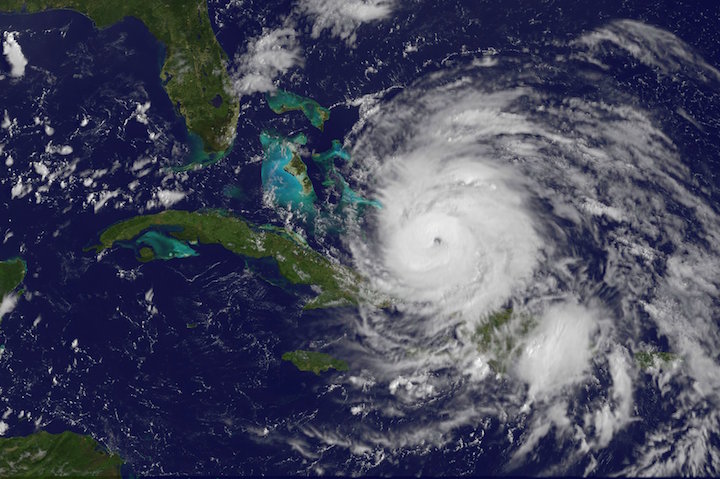
Hurricane Sandy 2012 (Image Courtesy of the National Hurricane Center-Public Domain)
|
In less than a week, the 2017 North Atlantic hurricane season will officially begin and during this time most Bahamians are a bit uneasy due impart to the recent powerful and very devastating Hurricanes Matthew which struck many of the islands in the NW Bahamas(New Providence, North Andros and Grand Bahama) and Joaquin which struck many of the islands in the Central and SE Bahamas(Acklins, Crooked Island, Rum Cay, San Salvador,Inagua and Long Island). I had a chance to speak to several of the hurricane experts within the region about the outlook for the 2017 season.
Colorado State University(CSU) hurricane researchers Phil Klotzbach and his team in April were predicting a slightly below-average Atlantic hurricane season in 2017, citing the potential development of El Niño as well as recent anomalous cooling in the tropical Atlantic as primary factors. They stated that a weak La Niña this past winter has dissipated, and there is the potential that a weak to moderate El Niño could develop by the peak of the North Atlantic hurricane season. El Niño tends to increase upper-level westerly winds across the Caribbean into the tropical Atlantic, tearing apart hurricanes as they try to form.
In addition, most of the North Atlantic has anomalously cooled over the past month, and the tropical Atlantic is now slightly cooler than normal. In addition to providing less fuel for tropical cyclone formation and intensification, cooler tropical Atlantic sea surface temperatures are associated with a more stable atmosphere as well as drier air, both of which suppress organized thunderstorm activity necessary for hurricane development.The CSU Tropical Meteorology Project team is predicting 11 named storms during the Atlantic hurricane season, which runs from June 1 to November 30. Of those, researchers expect four to become hurricanes and two to reach major hurricane strength (Saffir/Simpson category 3-4-5) with sustained winds of 111 miles per hour or greater.
In an interview with Phil Klotzbach, he stated, "Our next seasonal hurricane forecast from CSU comes out on June 1. While I can't divulge the exact numbers until then, we are going to increase our forecast and call for a near-average season. At this point, I think the odds of a moderate El Nino are reduced compared with what we thought in early April. The tropical Atlantic has also anomalously warmed, leading to potentially more conducive Atlantic hurricane conditions."
According to Chris Landsea, the Science and Operations Officer at the National Hurricane Center, at the National Hurricane Center stated that "NOAA's(the National Oceanic and Atmospheric Administration)Climate Prediction Center has issued its annual 2017North Atlantic hurricane season outlook.
The season runs from June 1 through November 30. NOAA predicts a 70 percent likelihood of 11 to 17 named storms (winds of 39 mph or higher), of which 5 to 9 could become hurricanes (winds of 74 mph or higher), including 2 to 4 major hurricanes (Category 3, 4 or 5; winds of 111 mph or higher). It must be noted that we already had a named storm Arlene in April of this year.
An average season produces 12 named storms of which six become hurricanes, including three major hurricanes. For the upcoming Atlantic hurricane season, which runs from June 1 through November 30, forecasters predict a 45 percent chance of an above-normal season, a 35 percent chance of a near-normal season, and only a 20 percent chance of a below-normal season."
According to Hurricane Specialist at The Weather Channel, Mr. Bryan Norcross,he stated that when it comes to the 2017 season, "The thinking is that El Niño is going to be in a neutral to slightly positive state. So that will have something between a slight negative effect to little or no effect. The Atlantic water temperatures are warm and expected to stay warm, so that has a positive effect, but is not as big a factor as the El Niño. Thus the forecast of average, if the El Niño develops, to more than average if it is closer to neutral.In 2004, for example, the El Niño was slightly positive, and we had a busy year."
Matthew last year hitting both New Providence and Grand Bahama, did more for sensitizing Bahamians about the impact of hurricanes that all 11 of my books on Bahamian hurricanes didn't do combined.For example, many Bahamian residents didn't prepare for a major hurricane and they paid a significant price for it. For example, after Hurricane Matthew there were extremely long lines at the local gas stations and so too were the long lines at the major Nassau and Freeport restaurants, long lines at the food stores and ice companies. In preparing for a hurricane, one should stock up on food items and fill their vehicles with gas and it was obvious that many of these persons didn't do and they paid the price for their unpreparedness.
As a forecaster at the Bahamas Department of Meteorology, I must state that this means specifically very little for the Bahamas. The forecast does not predict if the Bahamas will be hit by a hurricane. For example, when Hurricane Andrew struck the Bahamas, it struck during a very inactive season in 1992. The 1992 season produced only six named storms and one subtropical storm. However, one of those named storms was Hurricane Andrew, which devastated The Bahamasas a Category 5 hurricane.In 1992, the first named storm did not form until August, and it was Hurricane Andrew, which devastated The Bahamas with well over $250 million in damage becoming one of the costliest hurricanes in Bahamian history only behind Hurricanes Matthew in 2016 and Floyd in 1999.
In other words, a season can deliver many storms, but have little impact, or deliver few storms and have one or more hitting The Bahamas coast with major impact.In another example, the 2010 hurricane season was above average with 19 named storms and 12 hurricanes in the Atlantic Basin.
Despite the busy season, not a single hurricane and or tropical storm made landfall in The Bahamas. So even if it does end up being an active hurricane season overall, the Bahamas might not be impacted. As an author of 11 books on Bahamian hurricanes, I must state that the best plan of action is to be prepared this year - like every year - for a possible hurricane strike in The Bahamas.
There is no strong correlation between the number of storms or hurricanes and Bahamian landfalls in any given season. One or more of the 11-16 named storms forecast to develop this season could hit The Bahamas, or none at all. Therefore, residents of The Bahamas should prepare each year no matter the forecast.
Wayne Neely is a certified Meteorologist working at the Department of Meteorology in Nassau for over 22 years. He is also an international speaker, best-selling author, lecturer on hurricanes, educator, and meteorologist. He can be reached at wayneneely@hotmail.com

© Copyright 2017 by thebahamasweekly.com
Top of Page
|
|
|
|


