NASSAU, The Bahamas – (Sunday, November 8, 2015) The National
Emergency Management Agency, NEMA, remains partially activated as it monitors a
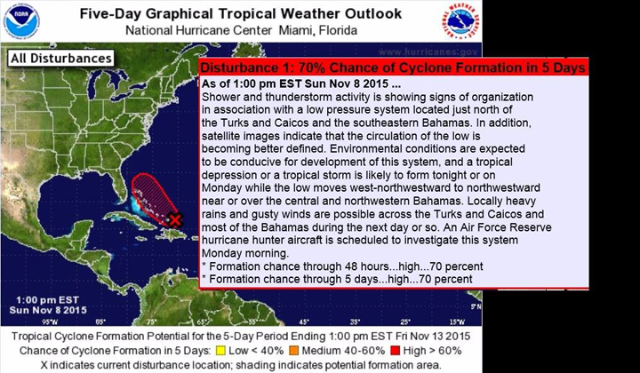
new developing system just north of the Turks and Caicos Islands and the
Southeastern Bahamas which includes, Inagua, Mayaguana, Acklins Island, Crooked
Island, Long Cay, Samana Cay, Ragged Island, Long Island, The Exumas, Rum Cay,
San Salvador and Cat Island.
NEMA had fully activated its
National Emergency Operations Centre (NEOC) during the passage of Hurricane
Joaquin in October and had down- graded to partial activation as the repairs,
recovery and reconstruction phases were being implemented.
Those island impacted by the category 4 Hurricane Joaquin were:
Acklins, Crooked Island, San Salvador, Long Island, Ragged Island, Mayaguana
and Rum Cay, affecting the lives of an estimated 5,000 residents.
On Friday, November 6, once The Bahamas Department of Meteorology
informed NEMA of the developing system, Family Island Administrators were
notified and encouraged to continue to monitor the system as it develops.
On Sunday, November 8, 2015 Director of NEMA Captain Stephen
Russell and a core team were on standby at NEMA’s office on Gladstone Road and
NEMA’s Way, to continue to monitor the system and to keep the public abreast of
the situation.
At 2pm Sunday, the Met Department issued a “Special Weather
Bulletin” on the system, which if continues to strengthen would become Tropical
Storm Kat
The Bahamas Department of Meteorology continues to monitor the
area of disturbed weather located near the Southeast Bahamas and the Turks and
Caicos Islands.At
1:00pm
Sunday, November 8, 2015, the National Hurricane Center has
advised that the showers and thunderstorms, associated with an area of low
pressure just north of the Turks and Caicos Islands and the Southeast Bahamas
is showing signs of organization.
In addition, satellite images indicate that the circulation of
the low is becoming better defined. An Air Force Reserve Hurricane Hunter
Aircraft is scheduled to investigate this system
on Monday
morning.
Environmental conditions are
expected to be favourable for a Tropical Depression (#12) or Tropical Storm
(Kate) to form from this system
tonight
(Sunday) or
on
Monday,
while the low moves west-northwest or northwest near or over the Central and
Northwest Bahamas.
Regardless, residents in the Turks & Caicos Islands and in
the Southeast and the Central Bahamas, which includes the islands of Inagua,
Mayaguana, Acklins Island, Crooked Island, Long Cay, Samana Cay, Ragged Island,
Long Island, The Exumas, Rum Cay, San Salvador and Cat Island
should expect locally heavy
rains and strong gusty winds and should be prepared to take quick action in the
event a Tropical Storm Warning may be issued sometime today.